Showing posts with label Railpath. Show all posts

Friday, November 16, 2012

Technology Harvests Energy from Railroad Train Vibrations

Stony Brook University engineers have won a national award. The award was entitled" Energy Harvesting" at the Energy Harvesting and Storage USA 2012 conference.

The group researched process and equipment to create an energy harvester that converts the irregular, oscillatory motion of that trains make as they travel over rail track. The system converts the vibrations into regular, unidirectional motion, in the same way that an electric voltage rectifier converts AC voltage into DC.


Top savings from the installation and use of the new invention...according to the researchers...,

save more than $10 million in trackside power supply costs for railroads in New York State alone.

along with a reduction of 3000 tons per year of CO2

and a half million dollars of electricity savings.

"With the MMR design, the technology advances the traditional energy harvesting, including directly generating high-quality DC power without an electrical rectifier in the vibration environment; enabling an electrical generator to rotate in one direction with relative steady speed in a more efficient speed region; and changing the negative influence of motion inertia into positive, thus reducing the mechanical stress and increasing system reliability," he said. "Such a design not only avoids the challenges of friction and impact induced by oscillation motion, but also enables us to make full use of the pulse-like features of track vibration to harvest more energy."says Professor Zuo

Here's the abstract of the presented paper. The blog will finish reading the paper and update this post with images and extracts.

ABSTRACT

Anelectromagnetic energy harvester is designed to harness the vibrational power from railroad track deflections due to passing trains. Whereas typical existing vibration energy harvester technologies are built for low power applications of milliwatts range, the proposed harvester will be designed for higher power applications for major track-side equipment such as warning signals, switches, and health monitoring sensors, which typically require a power supply of 10 Watts or more. To achieve this goal, we implement a new patent pending motion conversion mechanism which converts irregular pulse-like bidirectional linear vibration into regulated unidirectional rotational motion. Features of the motion mechanism include bidirectional to unidirectional conversion and flywheel speed regulation, with advantages of improved reliability, efficiency, and quality of output power. It also allows production of DC power directly from bidirectional vibration without electronic diodes. Preliminary harvester prototype testing results illustrate the features and benefits of the proposed motion mechanism, showing reduction of continual system loading, regulation of generator speed, and capability for continuous DC power generation.

Junctioneer.ca

Location:Quebec Ave,Toronto,Canada

Thursday, April 5, 2012

Junction Rd / Weston Rd shutdown to last for months more.

The west Toronto Diamond separation projection will keep the Junction Rd / Weston Rd roadway shutdown to last for months more.

This section of the airport rail link involves the construction of a major underpass where one railroad track will pass over another.

Historically the trains traveled over trackage that crossed each other at a level crossing, requiring one train to stop while another passed.

All this construction will remove this rail travel limitation.


The congestion this construction causes it appears to be a major headache for the local police who have to come down to southern part of their division by Keele St only.


The reopening of the Junction Rd / Weston Rd way will allow the police a much quicker travel way into the south end of their division.


So what's the work at the Junction Rd / Weston Rd diamond separate now.

Here are a number of photographs of the site currently. The large round objects are the concrete filled steel tubes that will
form the barrier wall as the dig out the ground to form the underpass.


The following images are of sound deadening shrouds used during the driving in of the steel piles.


The blog intends to put a page of all the image being sent in once the uploading issue presently troubling the blog is fixed.

Monday, February 27, 2012

Bike superhighways just what Toronto needs and probably will never see.

[caption id="attachment_10508" align="aligncenter" width="499" caption="Blue painted area is bike superhighway for cyclists"][/caption]


The City of London just announced that because of the opening of two bike superhighways in July of 2010 bike traffic is up 70% on two major thoroughfares in London in the year following. Build to get people on bikes instead of in their cars laying down safe, straightforward  cycling paths from outer neighborhoods into the city. They plan to  install an easy to navigate cycling super numerical series of such super pathways.

Read more: London's Bike Superhighways Help Bike Traffic Increase by 70% | Inhabitat - Green Design Will Save the World

Read More: concerning the input of cyclists in the design of the Bike superhighways

Other cities have built such roadways for decades such that they are a normal part of the transportation choices for people in the  Netherlands - which didn't get its extensive network of separated bicycle facilities overnight—it took decades [1.source]

Another city - Portland—which may spend $600 million on bicycle infrastructure over the next 20 years, with a goal of upping the cycling rate to 25 percent of all trips by 2030—that has most energetically taken on the bicycle boulevard concept...[1.source]

And further...

Sweden Plans A New Superhighway For Cyclists


Those Scandinavians are so cutting edge and bike friendly. Now they’re going a step further, connecting two cities with a major artery that’s for bikes only. [2.source]


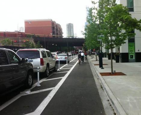
Chicago has a series of  protected bike lanes which probably would be a good idea for your Toronto with its car non-centrism around the rights of people moving and people driving.


[caption id="attachment_10504" align="aligncenter" width="469" caption="Protected bike lanes are designed with all kinds of people in mind, Chicago,  Click image to visit source of image site, livininthebikelane.blogspot.com"]Protected bike lanes are designed with all kinds of people in mind.[/caption]


Transport for London's Cycle Superhighways site click here to view.

Tuesday, December 27, 2011

Bridge link over the tracks always wanted in the Junction ...another close by west end community gets one.

[caption id="attachment_9802" align="aligncenter" width="500" caption="King Liberty Pedestrian/Cyclist Link location map...click on image to go to the cities site on this project"][/caption]


One of the 1st items many people who come to live in the Junction wish for is a bridge over the tracks to connect the two areas north and south of  Canadian Pacific Railway tracks. This has been an always ongoing discussion in the Junction and while there are some locations for the ground fall of the bridge on the north side of the tracks there are few if any on the south side.

This want/need? in bound to get even more community interest as development on the north side of tracks increases. Although this author can see such as bridge, ...which the author is not so interested in having but wonders if it would be a good community addition... would service a very small section of the the community.

A railroad bridge in the Junction would probably be well used residents just north of Annette St. Would those people living south of Annette St. walk or ride over the bridge enough to justify building a bridge, and would northern residents come south over the bridge?


..well here the info on the King Liberty area Railroad topping bridge....

full study link at City of Toronto site

full study link at this blog


The City of Toronto undertook the

 “Toronto West-Central Area Strategic

Transportation

Network Review” in 2006 and identified

 the need to better integrate the communities
north and south of the CN/GO railway corridor

between Atlantic Avenue and Strachan
Avenue. At its meeting of February 13, 2007,

 Toronto and East York Community Council
in considering a further report on a proposed

 pedestrian link at this location (TE3.45)
recommended that Transportation Services

 undertake an Environmental Assessment (EA)
study for a Pedestrian Link between King

 Street West and Liberty Village.


This item was considered by Public Works and Infrastructure Committee

 on November 3, 2011 and was adopted with amendments.

It will be considered by City Council on November 29, 2011.


further in package  Reference Drawings / Plans / Profiles appendix_e_reference_drawings and Stage 1 Archaeological Assessment appendix_d_arch_assessment

same files as package hosted at this blog

Tuesday, December 13, 2011

CN and CPR history book a great railroad community read


Rails Across Canada: The History of Canadian Pacific and Canadian National Railways  by Tom MurrayVoyageur Press | 2011 | ISBN: 0760340080 | 320 Pages | PDF | 155 MB


$22.50 Flexibound  and ebook edition


Publishers text

Few stories in the annals of railroading are as compelling as the construction, evolution, and astounding successes of the Canadian Pacific and Canadian National railways. This sprawling volume combines two of Voyageur Press' most successful Railroad Color History titles into one volume taking in the grand scope of both railroads. Author Tom Murray presents fastidiously researched and concisely presented histories of each railroad, along with more than 300 photographs, including rare archival black-and-white images and modern and period color photography sourced from national archives and private collections.

Tuesday, July 26, 2011

ELSEWARE ...winners of high speed rail comp

ELSEWARE is going to be a part of the blog  posting links to articles with similar happenings in the Junction.

This one is about a completion to discuss and provide ideas about high speed rail as as the  West Toronto Diamond project.


Click on the image to go to the site.

[caption id="attachment_8364" align="aligncenter" width="490" caption="click on the image to go to the site, this author really enjoyed the HOU(S)TATION configures a new suburban morphology founded on the logics of high-speed rail. article and the The Effect of High-Speed Rail on Six Lives proposes an ad campaign aimed at the high-speed rail public. By demonstrating the diverse set of people who could benefit from HSR, the project reminds us how personal transportation really is article."][/caption]

Monday, April 5, 2010

Railpath.... wet beauty

DSC00782

This image of the  Railpath gives rise to the though of what a great idea the path was and is. In addition is serves as a monument to the  greatness of the work of all the people who made it a reality.

At this point in the path route their is a large paved tarmac path as well as an expanse of trees and vegetation.

Oh not to forget the exciting trains to the right!

Saturday, January 9, 2010

FUZZY BOUNDARIES MEETING (Jan. 14)

09-01-2010 7-44-42 PM

Meeting announcement from the Fuzzy Boundaries group:

More than a year ago, a residents' group called Fuzzy Boundaries asked
the community to name the neighbourhood, and since then more than 200
ideas have been put forward.

You are invited to our third public meeting, where residents will make
their pitch for a favourite name.

There will be no keynote speaker, just a gathering of neighbours
exchanging ideas. Brockton Addition? Junction Triangle? The Railpath?
As always, it promises to be a lively and engaging discussion.
Afterwards, vote for your choice January 15 to 29 at
www.fuzzyboundaries.ca or at the Perth/Dupont Library.

When?: Thursday January 14, 7pm, at 45 Ernest Avenue (the new Boys and
Girls Club location).

All are welcome to attend this free event.

For details, call Kevin at 416-537-1128 or visit
www.fuzzyboundaries.ca where discussions about our great neighbourhood
take place online.

Friday, October 30, 2009

West Toronto Railpath Park Official Opening Ceremonies today


Councillor Adam Giambrone invites you to the official opening of the West Toronto Railpath Park on Friday, October 30, 2009. Councillor Giambrone, the City of Toronto, and Friends of the West Toronto Railpath are pleased to open the first 2.1 km of this exciting recreational trail.


  • Date: Friday, October 30, 2009

  • Location: West Toronto Railpath entrance at Wallace Avenue (south of Dupont, west of Perth, north of Bloor)

  • Time:

    • 2:00 p.m. – Opening Remarks

    • 2:15 p.m. – Official Ribbon Cutting Ceremony

    • 2:20 p.m. – cyclists gathered ride the trail and enjoy the sculptures

    • 2:25 p.m. – interested participants invited walk 2.1 km and explore the trail and sculptures


  • RSVP: Toronto Protocol RSVP Line 416-392-7667


The West Toronto Railpath Park is a new 2.1 kilometre multi-use trail that is perfect for cyclists, joggers, and people out for a stroll. Travelling alongside the railway corridor, it features extensive naturalized landscaping to create an appealing public space.
In addition to 2.1 km of park trail, designed by innovative Toronto-based firm Scott Torrance Landscape Architect Inc., the project includes four site-specific sculptures by renowned Toronto artist, John Dickson. The artwork series, Frontier, is inspired by the changing landscape of the Junction Railpath area. John Dickson was selected to work collaboratively with Scott Torrance Landscape Architects Inc. through an open competition coordinated by Toronto Cultural Services’ Public Art Office.
The Friends of the West Toronto Railpath is a community-based working group with the goal of assisting the City of Toronto finance, design and build a 6.5 kilometre path from Toronto’s Junction Neighbourhood into the heart of downtown Toronto and the shoreline of Lake Ontario.


Once future phases of the Railpath are built, it will be both a linear park and a sustainable transportation corridor, giving more than 250,000 Toronto residents a car-free path directly into the Toronto’s downtown core.Toronto Railpath Park Official Opening Ceremonies

Councillor Adam Giambrone invites you to the official opening of the West Toronto Railpath Park on Friday, October 30, 2009. Councillor Giambrone, the City of Toronto, and Friends of the West Toronto Railpath are pleased to open the first 2.1 km of this exciting recreational trail.

Date: Friday, October 30, 2009

Location: West Toronto Railpath entrance at Wallace Avenue (south of Dupont, west of Perth, north of Bloor). See attached map.

Time: 2:00 p.m. – Opening Remarks

2:15 p.m. – Official Ribbon Cutting Ceremony

2:20 p.m. – cyclists gathered ride the trail and enjoy the sculptures

2:25 p.m. – interested participants invited walk 2.1 km and explore the trail and sculptures

RSVP: Toronto Protocol RSVP Line 416-392-7667

The West Toronto Railpath Park is a new 2.1 kilometre multi-use trail that is perfect for cyclists, joggers, and people out for a stroll. Travelling alongside the railway corridor, it features extensive naturalized landscaping to create an appealing public space.

In addition to 2.1 km of park trail, designed by innovative Toronto-based firm Scott Torrance Landscape Architect Inc., the project includes four site-specific sculptures by renowned Toronto artist, John Dickson. The artwork series, Frontier, is inspired by the changing landscape of the Junction Railpath area. John Dickson was selected to work collaboratively with Scott Torrance Landscape Architects Inc. through an open competition coordinated by Toronto Cultural Services’ Public Art Office.

The Friends of the West Toronto Railpath is a community-based working group with the goal of assisting the City of Toronto finance, design and build a 6.5 kilometre path from Toronto’s Junction Neighbourhood into the heart of downtown Toronto and the shoreline of Lake Ontario.

Once future phases of the Railpath are built, it will be both a linear park and a sustainable transportation corridor, giving more than 250,000 Toronto residents a car-free path directly into the Toronto’s downtown coreWest Toronto Railpath Park Official Opening Ceremonies

Councillor Adam Giambrone invites you to the official opening of the West Toronto Railpath Park on Friday, October 30, 2009. Councillor Giambrone, the City of Toronto, and Friends of the West Toronto Railpath are pleased to open the first 2.1 km of this exciting recreational trail.

Date: Friday, October 30, 2009

Location: West Toronto Railpath entrance at Wallace Avenue (south of Dupont, west of Perth, north of Bloor). See attached map.

Time: 2:00 p.m. – Opening Remarks

2:15 p.m. – Official Ribbon Cutting Ceremony

2:20 p.m. – cyclists gathered ride the trail and enjoy the sculptures

2:25 p.m. – interested participants invited walk 2.1 km and explore the trail and sculptures

RSVP: Toronto Protocol RSVP Line 416-392-7667

The West Toronto Railpath Park is a new 2.1 kilometre multi-use trail that is perfect for cyclists, joggers, and people out for a stroll. Travelling alongside the railway corridor, it features extensive naturalized landscaping to create an appealing public space.

In addition to 2.1 km of park trail, designed by innovative Toronto-based firm Scott Torrance Landscape Architect Inc., the project includes four site-specific sculptures by renowned Toronto artist, John Dickson. The artwork series, Frontier, is inspired by the changing landscape of the Junction Railpath area. John Dickson was selected to work collaboratively with Scott Torrance Landscape Architects Inc. through an open competition coordinated by Toronto Cultural Services’ Public Art Office.

The Friends of the West Toronto Railpath is a community-based working group with the goal of assisting the City of Toronto finance, design and build a 6.5 kilometre path from Toronto’s Junction Neighbourhood into the heart of downtown Toronto and the shoreline of Lake Ontario.

Once future phases of the Railpath are built, it will be both a linear park and a sustainable transportation corridor, giving more than 250,000 Toronto residents a car-free path directly into the Toronto’s downtown core.

Monday, October 19, 2009

Josh Barndt, facilitator of the Dupont bike mural speaks at JRA cultural meet


The Culture Committee welcomes guest speaker Josh Barndt, facilitator of the Dupont bike mural who will talk about what made that project a success, and share plans for a community mural in Parkdale/Roncesvalles. Other agenda items: Boom Times Spring Fling update, discussion of other local arts activities.

Mon, Oct 26, 7:30 pm at Wise Daughters for the next JRA Culture Committee meeting.

Thursday, October 15, 2009

Fuzzy Boundaries neighbourhood name tryouts chalked on the Railpath

Neighbourhood Name Tryouts

Name Suggestions Chalked from Dupont to Bloor in West Toronto Railpath Park

Who: Fuzzy Boundaries, a group of local residents spearheading a naming project in their West Toronto neighbourhood north of Roncesvalles and east of The Junction.

What: The inscription of all 185 name suggestions (to date) along a section of the West Toronto Railpath stretching from Dupont Street to Bloor Street.

Where: West Toronto Railpath

Wallace Avenue Foot Bridge Entrance

370 Wallace Avenue

When: Thursday, October 15, 2009

(On display all weekend or until the rain washes the slate clean)

Why: Engage the community in the naming project. Naming the neighbourhood gives us a collective identity – something to call our area as a whole – which in turn creates a sense of pride and ownership among residents. This unique display offers everyone a chance to see the names suggested so far and prompt additional ideas before the shortlist is drawn up in January.

Contact: Kevin Putnam

Fuzzy Boundaries

www.fuzzyboundaries.ca

Putnam@sympatico.ca


Neighbourhood Name Tryouts


Name Suggestions Chalked from Dupont to Bloor in West Toronto Railpath Park


Who: Fuzzy Boundaries, a group of local residents spearheading a naming project in their West Toronto neighbourhood north of Roncesvalles and east of The Junction.


What: The inscription of all 185 name suggestions (to date) along a section of the West Toronto Railpath stretching from Dupont Street to Bloor Street.

Where: West Toronto Railpath

Wallace Avenue Foot Bridge Entrance

370 Wallace Avenue


When: Thursday, October 15, 2009


(On display all weekend or until the rain washes the slate clean)

Why: Engage the community in the naming project. Naming the neighbourhood gives us a collective identity – something to call our area as a whole – which in turn creates a sense of pride and ownership among residents. This unique display offers everyone a chance to see the names suggested so far and prompt additional ideas before the shortlist is drawn up in January.


Contact: Kevin Putnam

Fuzzy Boundaries

www.fuzzyboundaries.ca


Putnam@sympatico.ca

Tuesday, October 6, 2009

An interview with ROB PRICHARD, METROLINX PRESIDENT AND CHIEF EXECUTIVE

The Globe and Mail online has a interview with ROB PRICHARD online here

Two local relevant section outtakes from the article

On meeting the Tier 4 emissions standards on its Georgetown corridor trains


GO Transit has ... an enviable record of adopting the best available diesel technology and the cleanest available diesel fuel in every stage in its evolution as an organization. We are known to the manufacturers as eager to see technological advances and open to embracing the best technology as it becomes available. So there's no change for GO. We think it is a price worth paying, whatever the price is. It is not our expectation that it will dramatically increase the price of the locomotives. The locomotives we are acquiring now, while Tier 2 certified, are in fact compliant with the Tier 3 standards already and we just are very much in favour of these further technological improvements to reduce the pollutants from the emissions from the vehicles and we're happy to pay the market price of that technology as it becomes available over the next few years. We do not believe it will double it, but we are happy to pay the increased costs to have a cleaner environment and less emissions.


On the electrification of the line


Our current estimate of the cost of electrifying the Georgetown line only is $1.5-billion. We estimate the cost of electrifying the GO system, including Lakeshore East and Lakeshore West and the other lines, to be somewhere between $7 and $10-billion. So those are our current estimates. We have announced a thorough study of the benefits, all the benefits, and costs of electrification of the GO system and its individual lines. We began that study in June with a community advisory council of scientists, environmentalists, community representative, engineers and others to advise us on how to properly scope a thorough study. That work is coming to a conclusion over the next two weeks. We expect to get the approval of our board of directors to then proceed with the full study pursuant to that scope of work and complete it by December of next year. as a result of that, we'll have a very clear case made of the health benefit, the environmental benefit, the transit benefits, the community benefits of electrification, and we'll have a clear view of the financial costs of electrification and of the engineering costs. That is, to electrify the corridor will require transmission lines. Do we bring the power to the corridor through some communities? Then we need to be frank and open about that. It requires putting wires above all the tracks which are going through communities, and we need to be frank about that. So we need all the costs and all the benefits on the table so that an informed decision can be made. We'll make all that work public and then, following public debate, the province can make a decision as to whether or not to make that investment, and if so, at what pace. Because you can't electrify the entire system at once, because we would have to do it in some sequence, and we want to make sure we do the most urgent lines first and then do it in the right sequence as well. So we think given the magnitude of the public investment required to electrify, we think it's prudent to spend a year doing a very thorough study of the issues before making a commitment to it. In the meantime, we're confident that using the Tier 4 diesel technology, we can expand services on the Georgetown line and do so in a way that's consistent with improving air quality.


Monday, March 23, 2009

Toronto's offical plan on rail corridors no longer required for rail uses

march-19-old-weston-rd-09-001


As things and uses are changing in the railways areas of wards 11,13,14,17, and 18 it may be prescient for everyone to take notice of the City of Toronto's view towards disused rail corridors, as set out in the official plan.  The Railpath project currently is being built on a  a railway corridor no longer used for railroad purposes.  maybe there are other uses of newly disused areas?

...from the Official Plan

The Official Plan designates the subject property as Utility Corridors (see Attachment 4).
Utility Corridors are hydro and rail corridors primarily used for the movement and
transmission of energy, information, people and goods. The Plan states that a hydro
corridor may also be used for secondary purposes such as parks, trails and parking and
that rail corridors no longer required for rail uses, are to be protected for future use as
public transportation routes, bicycle and pedestrian trails and telecommunications and
electrical corridors where appropriate.


Official Plan states that where appropriate, development or redevelopment on landsm nearby or adjacent to Utility Corridors will:

(a) Protect for access to any potential bicycle and pedestrian trail or park and open
space, and provide access where such a recreation facility exists; and
(b) Screen and secure the property edge through such measures as setbacks, fencing,
site grading, berms, landscaping, building treatment and construction techniques.

Thursday, March 5, 2009

West End RailPath needs a small effort from a lot of people right now

This is officially the longest  post ever on this blog and for good reason it concerns an important project that most of us in the community will use.  The Railpath. Posted as a comment by blog reader Scott, I asked him if I could place it on the blog  as a post.

Please read  it and take the time to send a  short email (the blog has provided a short sample one at the end of Scott's text and Scott has provide a longer one for download), Scott also provides the info at the end of his text

I wanted to pass on some important information regarding the West End RailPath and ask you for a few minutes of your time. The great news is that stage 1 should open on June 20 and we are planning a party or something. The even better news is that already people are using the path. If you don’t know what Railpath is then head to Railpath.ca . In a nutshell Railpath is the conversion of old Weston Rail Corridor land to a linear park that will have a bike path, indigenous plants, and seating—stretching from north of Dupont to the lake near the CNE.

[caption id="attachment_3016" align="alignright" width="300" caption="what the railpath will look like, Photo : Design by Scott Torrance Landscape Architects, from Friends of the West Toronto Railpath site"]what the railpath will look like, Photo : Design by Scott Torrance Landscape Architects, from Friends of the West Toronto Railpath site[/caption]

In terms of stage 2 which would take the path south from Dundas to the Lakefront by the CNE there is some work to be done and Railpath Volunteers are very busy in this process. As you may know there is currently a public consultation and an Environmental Assessment (EA) being done by the MetroLinx that entails plans for an rail link to the airport and expanded GO service in the rail corridor that runs along side Railpath. Many people were startled to discover that Metrolinx seemed to know nothing about Railpath (!) and there was some alarm about seeing stage 2 built if there was going to be new rail traffic in the corridor.

To its credit Metrolinx has quickly met with Railpath and City officials and there are more meetings coming up. To keep the story brief, there has been a good exchange of information and it seems a real interest on the part of Metrolinx to see stage 2 of the Railpath built. Yes there are a few technical problems that exist in the last few blocks of stage 2 but at least the plans are out and people are trying to find solutions. It may turn out that we can only get stage 2 to Sudbury street which is still pretty good but at this point everybody is working on a full to the lack solution. Metrolinx has become very receptive to Railpath issues and is trying to make sure room is left for completion to happen.

Here is where a few minutes of your time would be of help. Metrolinx got a fairly large amount of feedback from the community in the stage 1 AND in stage 2 areas stating that people wanted completion. It would still be good for them to hear from as many people as possible about how valuable people feel a COMPLETED Railpath would be to the entire West End of the city. Remember, a completed Railpath and expansion of the use of the rail corridor are NOT exclusive of each other; they should and can co-exist. In fact Railpath augments or compliments the increased use of rail instead of cars. It will just take them making sure that some space is left for stage 2 to happen. The City has already sent a letter expressing the importance of a completed Railpath so there is “official” support in place. If you could, could you take the time to send an email, even if it is brief, to Brian Peltier the Executive in charge of the EA for Metrolinx to let him know that you feel completion is important and that you would like to see Metrolinx be part of this completion. All emails to him will be noted and recorded as part of the EA and remember that Metrolinx has been receptive and helpful. THIS MUST BE DONE BY MARCH 15. (Include real your address in the email)

Brian Peltier, Executive Lead
brian.peltier@metrolinx.com
416-874-5959

Metrolinx has a very detailed look at the EA and what they want to do on their website ( http://www.metrolinx.com). Railpath.ca is not the best website ever made but you can find some good info and pix if you dig deep. As we get closer to opening stage 1 look for the site to finally get revamped.

If you have any questions let me know and the whole West End will thank you for helping completion happen. We are really close and every email will help. If you know people who live in the stage 2 area (think Dufferin and Dundas/Queen/King Dovercourt, Lansdowne, Parkdale) pass this email on and encourage them to email as well.

sample email... extrapolated from Scott's text. (of course add all the more that you think would help :-))


cut------------------------------------------------

Dear Brian Peltier,

Executive Lead- Metrolinx

I am writing to you about the West End RailPath project.

As resident in the area I  feel completion of this important community enhancing path is of great importance.  With this email I would like you to know  that I would  like to see Metrolinx be part of this completion.

Thank you,

your name

your street address

email to brian.peltier@metrolinx.com

cut -------------------------------------------------------------------

UPDATE: Scott has provided a fuly rounded out letter which you can use also {click here to download it}

Each and every day multiple hours I miss Matt and Nate

 He’s really does not answer my questions about Matt and Nate, No way, they know the truth